Category: <span>R&D Projects</span>

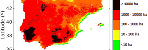
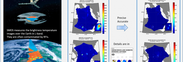
Modeling of Arctic Sea Ice

Arctic sea ice is segmented from SMOS brightness temperature observations based on a Bayesian unsupervised learning approach. The obtained classes can be analyzed in terms of their temporal stability and separability. The resulting spatial patterns are then related to different sea ice types and thickness Segmentation results for the period …

Fire risk

Fire risk index Based on SMOS-derived soil moisture (SM) and modelled land surface temperature (LST). Reports the risk of potential fire spread under particular SM/LST conditions. Accuracy: 83%. Maximum error: 40 ha. More information: Chaparro et al. (2016; JSTARS).     Fire occurrences & anticyclones Satellite soil moisture anomalies detect …

Multi-Sensor (GNSS-R / Optical) Airborne Experiment

First airborne optical and GNSS-R campaign conducted in the framework of the HUMIT project to test the readiness of the data fusion technique. Two separated regions of interest (ROIs) were defined: the surroundings of Balaguer and Tremp. The plane carried 4 different instruments: a hyperspectral sensor (AisaEAGLE-II), a thermal sensor …

GNSS-R Simulator

Online Simulation Tool Developed By: Hyuk Park, Adriano Camps, Yujin Kang and Manuel Martinez Getting Started: GARCA/GEROS Sim is a powerful tool. Get familiar below: Simulate Publications Manual and Guides Reliable The power of GEROS/GARCA Sim is available from any browser Accurate Results are generated from state of the art …

RFI Geolocation

Accurate and precise geolocation of RFI sources in the Passive Microwave Remote Sensing is essential to switch-off the RFI sources on the Earth. By using the Array Signal Processing (e.g. CAPON and MUSIC), the RFI sources in the Synthetic Aperture Interferometric Radiometer (e.g. SMOS and GIMS) can be geolocated accurately …

ONION Gap Analysis

The potential and promising payloads have been identified along with their technological challenges, providing an important scientific basis to address the measurement requirements, the instrumentation and remote sensing technologies that have to be explored to cover the next decade of the measurement gaps of the Copernicus system. This work was …

Payload Selection Simulator

An innovative hardware for mission analysis focused on payload selection from use cases and measurements requirements is being developed. This tool is based on machine learning model, where a database of the commercial platform and instruments missions (past, operational, planned, development) are taken into account to best decision making. Additionally, …

RF Interference detection and localization

Radio-Frequency Interference is a growing problem in many fields such as satellite communications and remote sensing. One way to help to solve this problem is to develop systems capable to detect and localize the interference source. The instruments PAU-SA and MERITXELL are microwave radiometers mounted in a mobile unit capable …